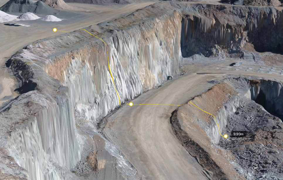
Measuring cross-sections is a common practice on work sites to plan and track earthworks, measure between designs, check gradients, measure distance, and verify utility locations. The Cross-Section Comparison tool in the desktop and mobile app shows a detailed profile view of your survey and allows elevation comparisons against other surfaces, linework, and models.
Create a cross-section measurement
From the measurement toolbar, select Cross-section from the Line tool's dropdown menu.
Draw a line across an area to create a cross-section to view. Click again to finish the line.

Resize or move the cross-section chart
You can control the height of your cross-section chart and adjust your view as needed. Hover over the top of the chart, then drag it up and down to resize.
For an enhanced viewing experience, you can open the cross-section chart in a separate, dedicated window to free up screen space for other content.
Click on the window icon in the Cross Section tab.
Click the X in the top corner to close it and return the chart to the main window. Then, minimize it by clicking the down arrow.
Export Your Cross-Section
To export the cross-section for use in other software, select the Download icon (a downward arrow) located in the top-right corner of the widget.
Types of cross-section measurements
Vertical
As you move along the cross-section line on the graph, the default view is the VERTICAL measurement of the survey surface.
Horizontal
Measuring the width of an area can be useful to determine the width of an excavation or whether a piece of equipment will safely fit.
Select HORIZONTAL from the drop-down menu to measure the width of where the cross-section measurement intersects the survey surface.
Tangent
Determining the tangent to different road gradients can be very useful on worksites. Using the cross-section tool, you can determine the tangent in DEGREES, as a RATIO or rise over run, or PERCENT of rise over run along a slope.
Change measurement units
Select the most appropriate measurement unit for distance, area, volume, and density from the dropdown menu. This makes it easy to move between imperial and metric units as needed and create reports in your preferred units.
Comparing cross-sections to another survey or design file
Comparing cross-sections to design files or other surveys across your site can be very useful for understanding and tracking earthwork progress, visualizing utility locations, and measuring distances between surveys and other design files.
Create a cross-section line as described in the directions above, or turn on a saved cross-section from the MEASURE tab.
Click the ADD DESIGN/SURVEY button and choose the designs and surveys you want to compare.
Import an IFC file with utility information to view underground utility cross sections. By default, the designs you selected that intersect with your cross-section line will be shown in the chart.
Use the color-coded legend to distinguish features in your cross-section. When you hover over an element in the chart, the same element is highlighted in the legend to identify layers easily.
By sliding your cursor across the cross-section line on the chart, you can see the elevation of the survey along the line.
If you need to resize the cross-section measurement panel, simply click and drag it to the desired size.
You can also see any linework, surface, or model in relation to your survey.
Use the drop-down to measure the Vertical, Horizontal, and Tangent (in degrees, ratio, or percent) between surveys and files.
Click the ADD DESIGN/SURVEY button to add more surveys or designs to view how this site has changed throughout a project.
To delete a survey or design, click the X next to the file's name.
Aspect Ratio
Change the aspect ratio to see a more or less exaggerated view of the cross-section. The 1:1 view makes it easy to view the cross-section with a true representation of the surface, whereas the 1:8 view will better highlight smaller elevation changes. Altering the aspect ratio is particularly useful when creating roadway cross-sections or conducting bench analyses.
Are you using alignments on your site? Learn more about referencing cross sections along an alignment by reading our article "How to Use Alignments."
I still can't do it!
We wrote these articles to equip you with everything you need to get the job done on your own, but we understand that sometimes this isn't sufficient.
If you're stuck, you can connect with our support team by clicking the question mark button at the top right corner of your user portal.
Related to